Flood Management System - Real-time alerts and community engagement

Flood Management System - Real-time alerts and community engagement

Bridging data and people — proactive flood management for all.

Bridging data and people — proactive flood management for all.

Bridging data and people — proactive flood management for all.

Real Impact, Real Growth

The government’s flood management system serves as a comprehensive database designed to predict water-related challenges and support proactive planning by authorities. The objective was to develop a platform that enhances statewide water resource management, ultimately benefiting residents in their daily lives. The application also strengthens community engagement by enabling citizens to report issues and access timely information.

The government’s flood management system serves as a comprehensive database designed to predict water-related challenges and support proactive planning by authorities. The objective was to develop a platform that enhances statewide water resource management, ultimately benefiting residents in their daily lives. The application also strengthens community engagement by enabling citizens to report issues and access timely information.

40%

Faster flood-response coordination

24/7

Real Time Monitoring

80%

Engagement on alerts & reports

Driving better flood management with real-time reports and critical water insights.

Year

2022-23

Industry

Climate & Sustainablity
Content
Content

Services Provided

Web & Mobile App Development, Product Design, Quality Assurance
Expert Plumber
Expert Plumber
Expert Plumber

The Challenge


  • To gather and combine information regarding the state's regular recorded rainfall, water levels, and water discharge into a single platform for the purpose of analysing, making decisions and having a record for lifetime.

  • To facilitate timely planning and action through personalised and instant alerts to different stakeholders

  • To establish a connection with the community to enhance flood management in specific regions and provide them with the ability to report incidents via the app.

The Solution

  • A unified platform that combines and analyses water data for informed decisions and long-term record-keeping.

  • An admin-only alert system that sends targeted notifications based on water levels, rainfall, and discharge.

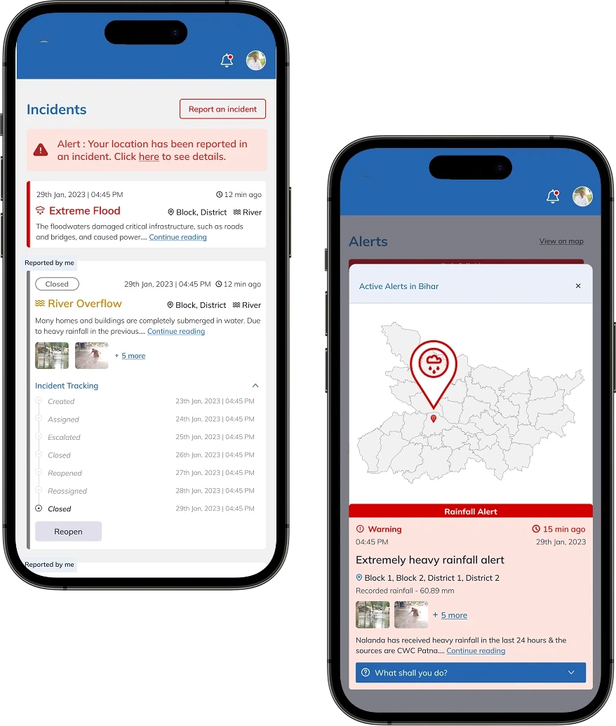
  • A transparent incident flow where the public reports issues, officials resolve them, and cases reopen until fully addressed.

Unified Data Platform

Admin-Driven Alert System

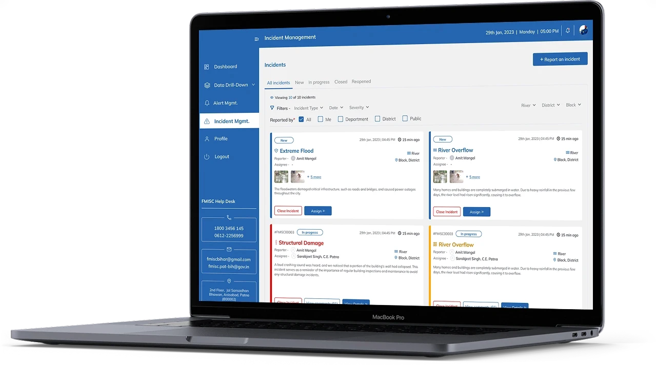
Transparent Incident Management

Community Engagement Platform

Expert Plumber
Expert Plumber
Expert Plumber

//

TECH STACK

//

TECH STACK

//

TECH STACK

Built on a Proven Tech Stack

A carefully chosen stack that powers performance, security, and long-term adaptability across every product we build.

React JS + Native
React JS + Native
React JS + Native
MUI
MUI
MUI
TYpescript
TYpescript
TYpescript
Larvel 9
Larvel 9
Larvel 9
ArcGIS
ArcGIS
ArcGIS

//

KEY FEATURES

//

KEY FEATURES

//

KEY FEATURES

Inside the Experience

Inside the Experience

Intelligent features designed to streamline workflows, elevate experience, and drive continuous growth.

Intelligent features designed to streamline workflows, elevate experience, and drive continuous growth.

Information Product Management

Lifelong, real-time records of integrated rainfall and water-level data.

Information Product Management

Lifelong, real-time records of integrated rainfall and water-level data.

Information Product Management

Lifelong, real-time records of integrated rainfall and water-level data.

Alert Management

Admin-controlled alerts for water data, complete with severity levels and targeted delivery.

Alert Management

Admin-controlled alerts for water data, complete with severity levels and targeted delivery.

Alert Management

Admin-controlled alerts for water data, complete with severity levels and targeted delivery.

Incident Management

A transparent system allowing incident tracking, official assignment, and case reopening when solutions fall short.

Incident Management

A transparent system allowing incident tracking, official assignment, and case reopening when solutions fall short.

Incident Management

A transparent system allowing incident tracking, official assignment, and case reopening when solutions fall short.

Real-time map interaction

Granular real-time maps displaying alerts and incidents based on the stakeholder’s location, role, and jurisdiction.

Real-time map interaction

Granular real-time maps displaying alerts and incidents based on the stakeholder’s location, role, and jurisdiction.

Real-time map interaction

Granular real-time maps displaying alerts and incidents based on the stakeholder’s location, role, and jurisdiction.